
Why so many of Africa's borders are straight lines
A third of Africa's borders are straight lines drawn by Europeans who never visited. Those lines still split peoples and fuel conflicts today.
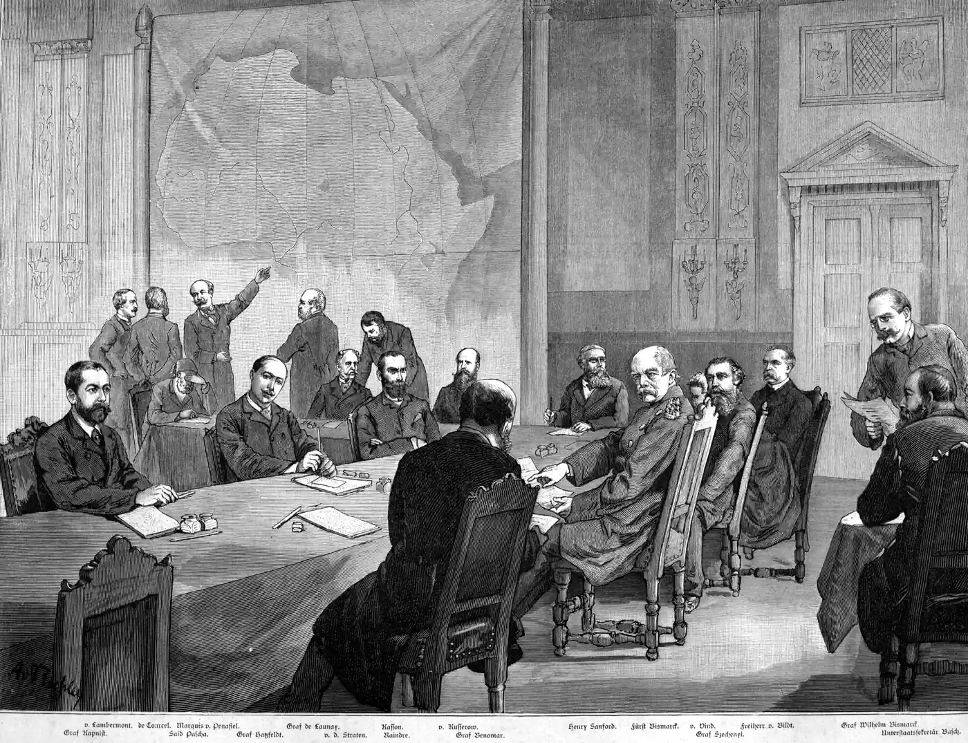
In 1890, the British prime minister Lord Salisbury described what he and the French had been doing across Africa. "We have been engaged in drawing lines upon maps where no white man's foot ever trod," he said. "We have been giving away mountains and rivers and lakes to each other, only hindered by the small impediment that we never knew exactly where the mountains and rivers and lakes were."
He was not exaggerating. Between 1884 and 1914, European diplomats carved Africa into roughly fifty territories, and about a third of the borders they drew are straight lines: arcs of latitude, stretches of meridian, or simple compass bearings running for hundreds of kilometers across terrain those diplomats had never seen, through peoples whose names most of them did not know. Almost every African state still lives inside the lines Europeans drew, because in 1964 the newly independent nations decided to keep them. What those lines cost has been adding up ever since.
How fourteen nations carved up a continent
The starting gun was the Berlin Conference of 1884 to 1885. Otto von Bismarck, the German chancellor, called it, not because Germany had large African ambitions yet, but because he wanted to keep Britain and France from fighting over the continent and dragging Europe in with them. Fourteen nations sent delegates, including the United States and the Ottoman Empire. Not a single African was invited. Only two of the delegates had ever set foot on the continent, which is three times the size of Europe.
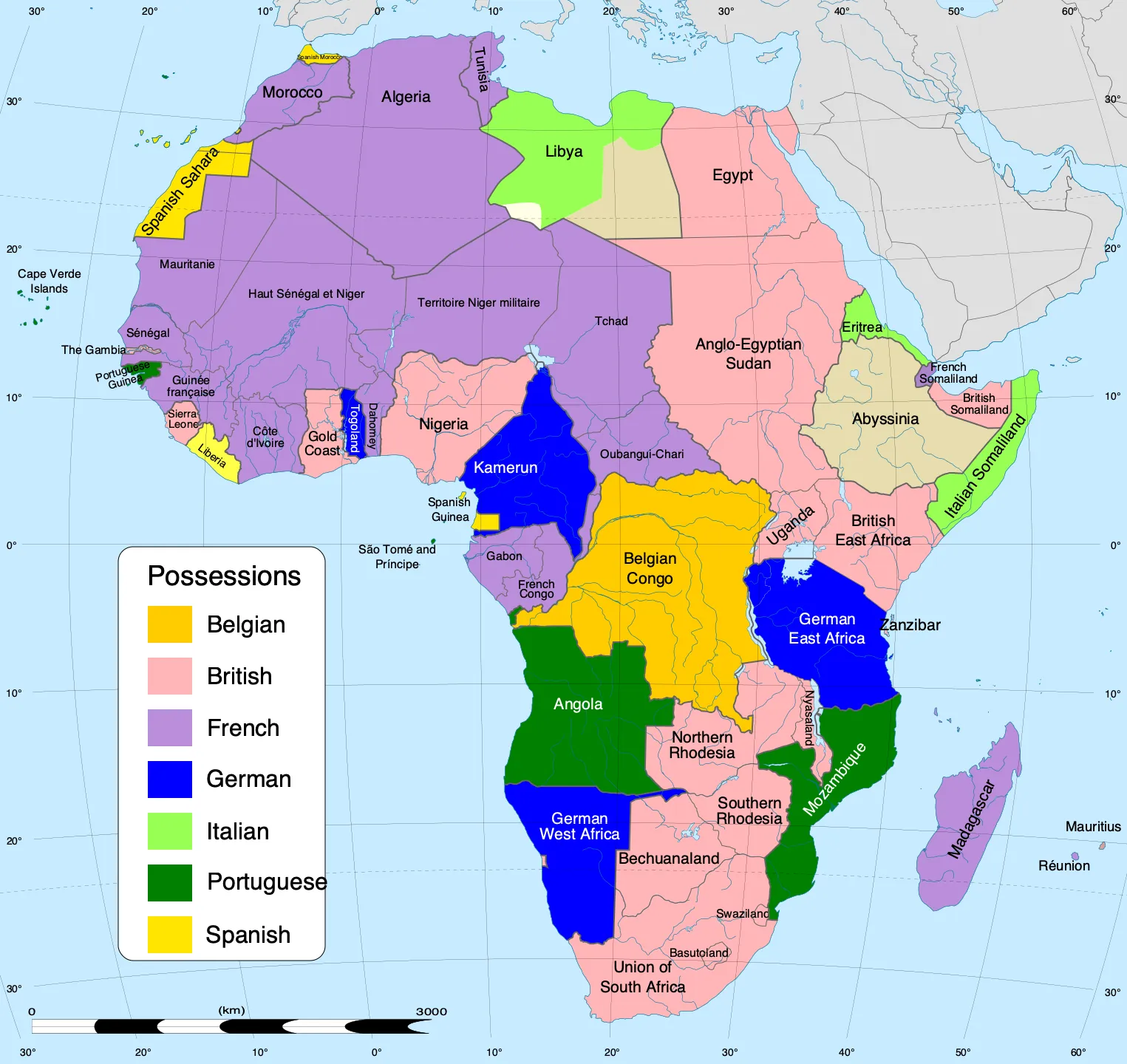
The conference did not draw most of the borders itself. What it did was write the rules of the game: any European power could claim African territory by "effectively occupying" it and notifying the others. Before Berlin, only about 20 percent of Africa was under European control. Within thirty years, in the Scramble for Africa, more than 90 percent was. France took the largest share, roughly a third of the continent, mostly in the west and north. Britain took east and southern Africa plus Nigeria. Germany took what became Togo, Cameroon, Tanzania, and Namibia. Belgium's King Leopold II took the Congo as a personal estate, not even a colony of his country, and ran it as a forced-labor operation so brutal that it killed millions.
The borders drawn in this rush were not random, but they were crude. Rivers and lakes make up about 63 percent of Africa's boundaries. But rivers run out, and where they did, diplomats reached for the simplest tool available: a ruler on a map. Latitude and longitude lines were drawn across the Sahara, through the Sahel, and across the savannas of East Africa. The border between Egypt and Libya runs straight south along the 25th meridian for nearly 700 kilometers. The border between Algeria and Mali follows a line that has nothing to do with either country's peoples or geography. These were not mistakes. They were shortcuts by men who did not know or care what was on either side.
What the lines cut through
The borders sliced through ethnic groups, trade networks, and kingdoms that had existed for centuries. The Yoruba, one of West Africa's largest peoples, ended up split between Nigeria, Benin, and Togo. The Maasai were divided between British Kenya and German Tanganyika, now Tanzania. The Somali people were partitioned across five territories: British Somaliland, Italian Somaliland, French Djibouti, the Ethiopian Ogaden, and Britain's Northern Frontier District in Kenya. The Tuareg, Saharan nomads who had moved freely across the desert for a thousand years, found themselves inside five different countries: Mali, Niger, Algeria, Libya, and Burkina Faso.
Some borders produced shapes that make no geographic or political sense at all. The Gambia is a narrow strip of land, never more than 48 kilometers wide, running along both banks of the Gambia River and surrounded entirely by Senegal. It exists because Britain controlled the river and France controlled everything around it, and in 1889 they agreed to split the difference. The Caprivi Strip, a thin finger of land that juts east from Namibia for 450 kilometers, was drawn in 1890 so that Germany could reach the Zambezi River from its colony in South West Africa. The plan was to open a river route to German East Africa. Nobody checked. Victoria Falls was in the way, and it made the Zambezi unnavigable.
Why Africa kept the borders
When African nations won independence in the 1950s and 1960s, they faced a choice: try to redraw the borders along ethnic or geographic lines, or accept the colonial map as it was. In 1964, the Organization of African Unity met in Cairo and chose the second option. The borders of each state, as they stood on the day of independence, would be treated as final.
The reasoning was practical. Africa has over a thousand ethnic groups and hundreds of languages. If one border opened for renegotiation, every border was in play, and the result would be war everywhere at once. Better to live with bad borders than to fight over better ones. The decision is the most counterintuitive move in African postcolonial politics: the countries that had suffered most from arbitrary borders were the same countries that voted to keep them. And with few exceptions, they have. Eritrea broke away from Ethiopia in 1993 after a thirty-year war. South Sudan separated from Sudan in 2011 after decades of civil war. Otherwise, the map of Africa today looks almost exactly the same as the one Europeans drew.
What those borders cost today
The cost is clearest in the Sahel, the dry belt that runs across Africa just south of the Sahara. Mali, Niger, Burkina Faso, and Chad each contain dozens of ethnic groups locked inside colonial borders that were drawn through the desert with no regard for who lived where. The Tuareg in northern Mali launched rebellions in the 1960s, the 1990s, and again in 2012, each time demanding autonomy from a government in Bamako, a thousand kilometers to the south, that had little authority over the north and little interest in it. Jihadist groups filled the gap. By 2026, all four Sahel countries are governed by military juntas that took power promising security and have delivered mostly more violence.
Around Lake Chad, the border between Nigeria, Niger, Chad, and Cameroon cuts through fishing communities and trading towns that have always functioned as one economy. Boko Haram, the jihadist group that grew out of northeastern Nigeria, operates freely across all four borders. About three million people in the Lake Chad Basin are displaced, and roughly 80 percent of Boko Haram's attacks happen within 50 kilometers of Nigeria's northern borders, exactly where the colonial lines run.
The pattern holds across the continent. The Congo Free State that Leopold II drew became the Democratic Republic of the Congo, a country the size of Western Europe with over 200 ethnic groups, no geographic logic, and a civil war in the 2000s that killed more people than any conflict since the Second World War. Nigeria's north-south fault line, between a Muslim Hausa-Fulani north and a Christian Yoruba-Igbo south, tracks the line the British drew when they merged two separate protectorates into one colony in 1914. The partition of India, bad as it was, at least tried to sort populations along religious lines. In Africa, nobody tried at all.
Lord Salisbury's lines are still on the map. The peoples they divided are still divided. The conflicts they seeded are still running, and in the Sahel and the Lake Chad Basin they are getting worse. Drawing a border across a people you have never met takes an afternoon. Undoing it, so far, has taken longer than the colonial period itself.
Test what you learned
5 questions on this article. About two minutes, no signup.