
Line of Control
The Line of Control is the 740-kilometer military line dividing Kashmir between India and Pakistan, drawn in 1949 and never accepted as a border.
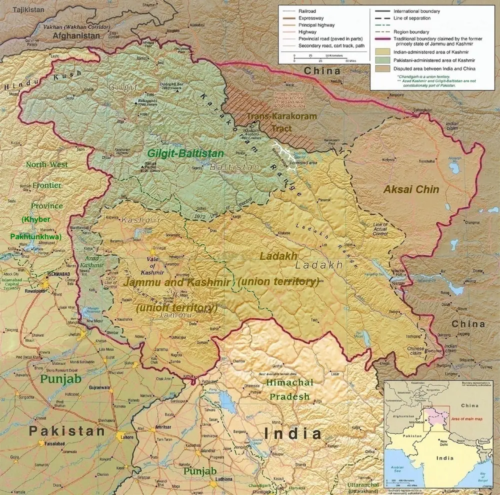
The Line of Control is the roughly 740-kilometer military line that divides the Kashmir region between India and Pakistan. It runs from near the plains of Jammu up through the Himalayas to a map reference called NJ9842, close to the Siachen Glacier. The line is not a border. Both India and Pakistan claim all of Kashmir, and neither accepts the line as anything more than the place where their armies stopped fighting. It was first drawn in 1949, at the end of the first war the two countries fought over Kashmir, and it has been one of the most heavily armed frontiers on Earth ever since.
How the Line of Control was drawn
When Britain left India in 1947 and the subcontinent was partitioned, hundreds of princely states had to choose between joining India or Pakistan. Kashmir was the hardest case. It was a Muslim-majority state ruled by a Hindu maharaja, Hari Singh, who wanted independence or at least time to decide. He got neither. In October 1947, tribal fighters backed by Pakistan invaded from the northwest. Hari Singh signed Kashmir over to India in exchange for military help, and Indian troops flew into Srinagar to stop the advance. They pushed the invaders back but could not drive them out entirely.
The fighting lasted over a year. On January 1, 1949, a ceasefire took hold. Neither army had won. The two armies held the ground they had when the shooting ended. A UN-brokered agreement signed in Karachi on July 27, 1949, turned that front into an official ceasefire line. The agreement mapped the line north "to the glaciers," but it stopped at the grid reference NJ9842. Beyond that point, nobody drew a boundary. That gap later became the fight over the Siachen Glacier, where troops occupy positions above 6,000 meters and more die from the cold than from combat.
India and Pakistan fought again in 1965 and in 1971. The 1971 war was fought mainly over East Pakistan, which became Bangladesh. It ended with 90,000 Pakistani soldiers surrendering. In the aftermath, Indian Prime Minister Indira Gandhi and Pakistani President Zulfikar Ali Bhutto met in the hill town of Simla and signed an agreement on July 2, 1972. It gave the ceasefire line a new name, the "Line of Control," and committed both sides not to change it by force. The new line traced almost exactly the same path as the original. In 1999, Pakistani soldiers crossed it in the mountains above Kargil. The short war that followed ended with Pakistan withdrawing back to the line.
Why is the Line of Control not a border?
The Line of Control is not an international border because neither India nor Pakistan will accept it as one. India's position is that all of the former princely state of Jammu and Kashmir belongs to India. That includes Azad Kashmir and Gilgit-Baltistan, which Pakistan administers. Pakistan's position is that all of Kashmir is disputed and that its future should be decided by a plebiscite, as the United Nations proposed in 1948.
The name itself reflects the disagreement. "Line of Control" is deliberately not "border." Neither government can accept the line as permanent without giving up its claim to the other side. Maps published in India show Pakistan-administered Kashmir as Indian territory. Maps published in Pakistan show the whole region as disputed. The line has stood for more than seventy-five years, but in legal and political terms, neither country considers it settled.
The Line of Control today
The line is fenced with razor wire and flanked by minefields and bunkers. Tens of thousands of troops are stationed on each side, on some of the highest terrain where armies operate anywhere in the world. Cross-border shelling was routine for decades. A ceasefire agreed in November 2003 held for several years, then broke down as violations climbed into the thousands each year. In February 2021, India and Pakistan agreed to a renewed ceasefire, and the line went quiet.
That quiet ended in 2025. In April, gunmen killed 26 people at a tourist site in Pahalgam, in Indian-administered Kashmir. India struck targets inside Pakistan, and Pakistan struck back. After four days of fighting, a ceasefire took hold.
For people living along the line, cycles of shelling and silence are daily life. On both sides, villages lie close enough to be hit by artillery from across the line, and families have built concrete shelters next to their houses. In April 2005, a bus service opened between Srinagar and Muzaffarabad, the first crossing in decades. It allowed divided Kashmiri families to visit relatives some had not seen since 1947. The service has been suspended in recent years.
The Line of Control has divided Kashmir for more than seventy-five years. Both India and Pakistan have nuclear weapons, and both have armies facing each other across a line that neither considers a real border.