
Sykes-Picot Agreement
The Sykes-Picot Agreement was a secret 1916 deal between Britain and France to divide the Ottoman Empire's Arab provinces.
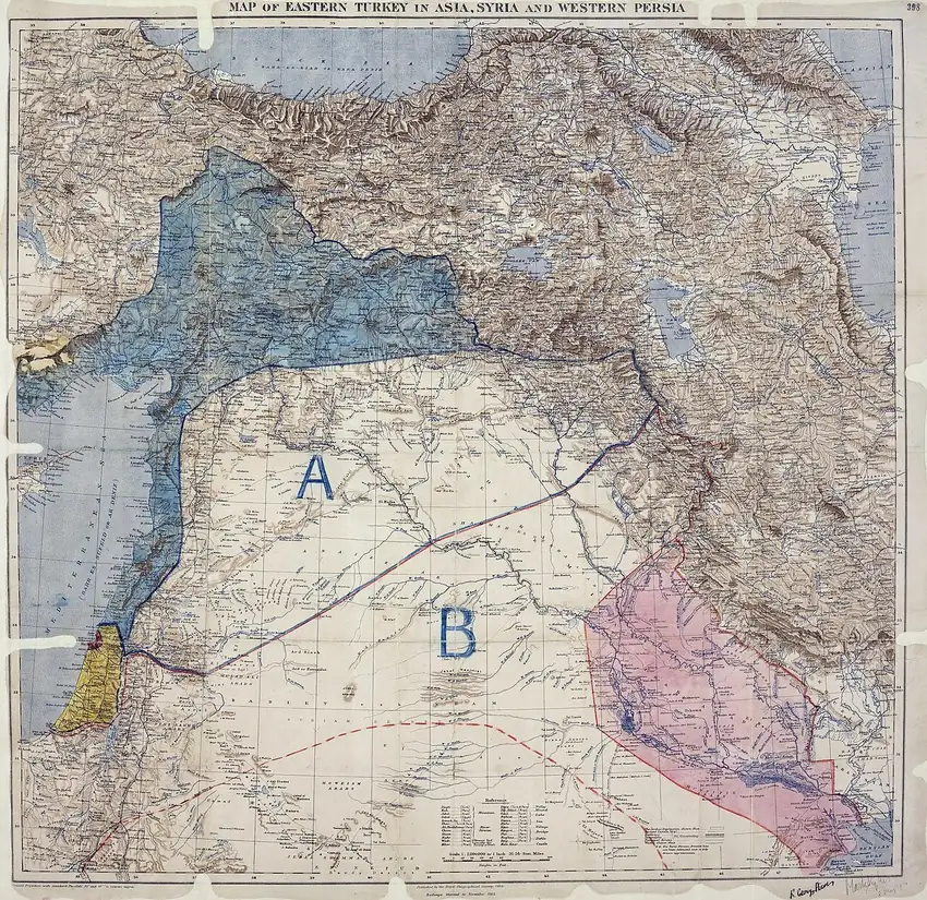
The Sykes-Picot Agreement was a secret deal made in May 1916 between Britain and France to divide the Arab provinces of the Ottoman Empire between them after World War I. The two governments carved out zones of control and influence across territory the two countries had mostly not conquered yet. The deal was named after its negotiators, Sir Mark Sykes and Francois Georges-Picot, and it was never meant to be public. It came to light in November 1917 when Russia's new Bolshevik government discovered it among the tsarist diplomatic archives and released it. The agreement did not produce today's Middle Eastern borders, but its name became the most recognized symbol of outside powers carving up the region for their own benefit.
How Sykes and Picot divided the map
Mark Sykes was a Yorkshire baronet and member of parliament who had traveled across the Ottoman Empire as a young man and wrote books about the region. He considered himself an authority on the Middle East. He would not live to see what came of his agreement: he died of the Spanish flu in Paris in February 1919, at age 39, while attending the peace conference that was supposed to settle the region's future.
Francois Georges-Picot had served as France's consul-general in Beirut before the war and came from a family involved in French colonial politics. He was convinced that France had a historical claim to Syria.
The map they produced in 1916 divided the region five ways. France received full authority over coastal Syria, Lebanon, and Cilicia, a strip of southern Anatolia, colored blue on the map. Britain received lower Mesopotamia, including Basra and Baghdad, as well as the Mediterranean ports of Haifa and Acre, colored red. Two large interior zones were set aside for one or more independent Arab states: Zone A in the north, under French influence, and Zone B in the south, under British influence. In those zones, France and Britain would have first claim on providing advisers and loans. Palestine, which every party wanted, was to be governed by an international body whose form was never defined.
Russia was consulted separately and was promised Istanbul, the Turkish Straits, and the eastern part of Anatolia. Italy joined the agreement in 1917. When the deal was signed, the Ottomans still held most of the territory on the map and were still at war.
How Sykes-Picot conflicted with Britain's other wartime promises
The agreement was one of three wartime commitments Britain made that could not all be honored.
In 1915 and 1916, Sir Henry McMahon, Britain's high commissioner in Cairo, exchanged letters with Hussein, the Sharif of Mecca, encouraging him to lead an Arab revolt against the Ottomans. In return, McMahon offered British support for Arab independence after the war. The letters were deliberately vague about which territories the promise covered, especially Syria and Palestine. Hussein launched the revolt in June 1916. British officers, including T. E. Lawrence, fought alongside his forces.
Sykes-Picot had been signed one month before the revolt began. It assigned much of the same territory to French and British control or influence.
The Balfour Declaration of November 1917 then pledged British support for "a national home for the Jewish people." The territory in question was Palestine. The agreement had proposed to internationalize it, and the Arabs expected to govern it themselves. The story of how Israel became a country starts with that pledge.
When the Bolsheviks released the secret treaties later that month, the documents reached Ottoman commanders, who forwarded them to Arab fighters serving on Britain's side. By 1918 the agreement's name had become a synonym for broken European promises.
Sykes-Picot and today's Middle Eastern borders
Sykes-Picot is often described as the agreement that created today's Middle Eastern borders, but many of its terms did not survive the postwar negotiations.
Russia left the war after the Bolshevik revolution, which canceled the territory promised to it. Mosul, which the agreement had placed in France's zone, ended up with Britain after a private conversation between British Prime Minister David Lloyd George and French Prime Minister Georges Clemenceau in December 1918. By then it was widely believed that Mosul sat on large oil reserves. Palestine became a British mandate, not the internationally governed territory the agreement had envisioned.
The independent Arab state that the agreement's Zone A and Zone B scheme was supposed to produce never appeared. In 1920, Faisal, a son of Sharif Hussein, was proclaimed king in Damascus. France sent troops to drive him out in July 1920. The British then installed him as king of Iraq in 1921.
Today's borders came instead from the San Remo conference of April 1920, the League of Nations mandate charters of 1922, and the Treaty of Lausanne of 1923, with further adjustments after that.
In June 2014, ISIS drove a bulldozer through the sand barrier separating Iraq and Syria. The group released a video titled "The End of Sykes-Picot." Sykes and Picot never drew that particular border, and their deal had been legally dead for about ninety years. But the name still serves as a label for the claim that European capitals, not local peoples, shaped the region's boundaries. The agreement's lasting legacy is not any line on its map but a precedent: two imperial powers arranging a region's future behind closed doors, producing countries whose borders served European rivalry, not the people who lived there.