
Disputed territory · South China Sea
Spratly Islands
Tense: clashes over Philippine supply runsUpdated November 1, 2026
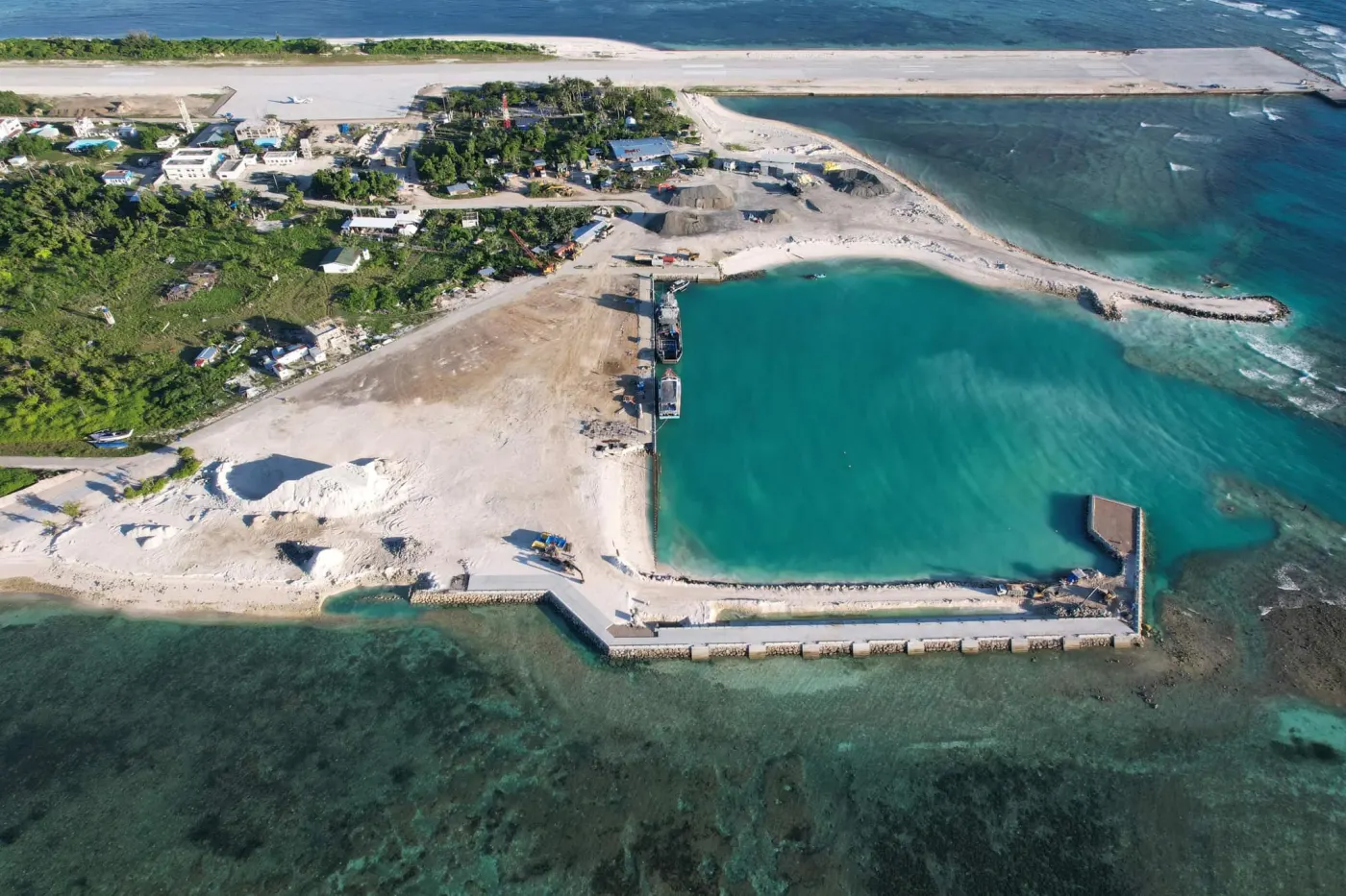
The Spratly Islands are more than 100 reefs, shoals and small islands in the southern South China Sea, spread over about 425,000 km² of water. Six governments claim some or all of them: China, Taiwan, Vietnam, the Philippines, Malaysia and Brunei. Five of them occupy features. By CSIS AMTI's count, Vietnam holds 21, the Philippines 9, China 7, Malaysia 5 and Taiwan 1. China has built the largest artificial islands, with three runways. China calls the islands Nansha, Vietnam calls them Truong Sa, and the Philippines calls the part it claims Kalayaan.
- Claimants
- 6
- China, Taiwan, Vietnam, the Philippines, Malaysia, Brunei
- Features occupied
- 43
- Vietnam 21, Philippines 9, China 7, Malaysia 5, Taiwan 1
- Natural land
- Under 2 km²
- China and Vietnam have built about 24 km² more
- China's artificial land
- About 13 km²
- built 2013-16 on seven reefs in the Spratlys
Spratly Islands in 30 seconds
- The Spratly Islands are more than 100 small reefs, shoals and islands in the southern South China Sea. Their natural land totals less than 2 km². The largest island, Itu Aba, held by Taiwan, is about 46 hectares.
- Vietnam holds 21 features, the Philippines 9, China 7, Malaysia 5 and Taiwan 1, by CSIS AMTI's count. Brunei claims a zone but holds nothing.
- China built three runways of about 3 km in the Spratlys from 2013 to 2016. Vietnam has since built almost as much artificial land. Vietnam, the Philippines, Taiwan and Malaysia each have shorter runways of their own.
- A 2016 tribunal ruled that no Spratly feature earns a 200-mile exclusive economic zone. China called the ruling null and void.
What are the Spratly Islands?
The Spratly Islands are a scattered group of more than 100 reefs, shoals, cays and small islands in the southern South China Sea. They spread over roughly 425,000 km² of water, an area larger than Germany. Most features are coral reefs that are underwater at high tide. The natural islands and sandy cays above high tide total less than 2 km².
The largest island is Itu Aba, which China and Taiwan call Taiping Island and Vietnam calls Ba Binh. It covers about 46 hectares. The second largest is Thitu, which the Philippines calls Pag-asa, China calls Zhongye and Vietnam calls Thi Tu. It covers about 37 hectares.
The islands sit on rich fishing grounds beside the shipping routes between the Strait of Malacca and East Asia. The sea floor may hold oil and gas, mostly around Reed Bank in the northeast of the group.
Names for the Spratlys
- EnglishSpratly Islands, after the British whaling captain Richard Spratly, who sighted Spratly Island in 1843
 ChinaNansha Qundao (Southern Sand Islands)
 VietnamQuan dao Truong Sa (Long Sand Islands)
 PhilippinesKalayaan Island Group (Freedom Islands), for the part it claims
 MalaysiaKepulauan Spratly
 TaiwanNansha Islands, the same name as China's
 VIETNAM
PHILIPPINES
MALAYSIA
BRUNEI
Palawan
Borneo
South China Sea
Sulu Sea
Thitu / Pag-asa
Subi Reef
Itu Aba / Taiping
Fiery Cross Reef
Johnson South
Mischief Reef
Second Thomas Shoal
Spratly Island
Barque Canada Reef
Swallow Reef
 VIETNAM
PHILIPPINES
MALAYSIA
Palawan
South China Sea
Thitu / Pag-asa
Subi Reef
Itu Aba / Taiping
Fiery Cross Reef
Mischief Reef
Second Thomas
Spratly Island
Barque Canada
Swallow Reef
Who occupies the Spratly Islands?
Five governments hold features in the Spratlys. Of today's occupiers, the Republic of China, now based in Taiwan, arrived first, in 1946. The Philippines followed in 1971, South Vietnam in the 1970s, Malaysia in 1983 and China in 1988. By CSIS AMTI's count as of August 2025, Vietnam holds 21, the Philippines 9, China 7, Malaysia 5 and Taiwan 1. Other sources count Vietnam's features differently.
China's seven features include Johnson South Reef, which China calls Chigua Jiao and Vietnam calls Gac Ma. Three have runways: Fiery Cross Reef, Subi Reef and Mischief Reef. China turned all seven into artificial islands between 2013 and 2016.
Vietnam's outposts include Spratly Island, which Vietnam calls Truong Sa Island and where it has its only runway in the group, and Southwest Cay (Song Tu Tay). The Philippines' main base is Thitu. The Philippine municipality of Kalayaan, based on Thitu, had 406 residents in the 2024 census. Philippine Marines also live aboard the BRP Sierra Madre, grounded in 1999 on Second Thomas Shoal, which the Philippines calls Ayungin and China calls Ren'ai Jiao.
Taiwan holds Itu Aba, where about 200 coast guard personnel are stationed. Malaysia holds five features in the south, including Swallow Reef (Layang-Layang), where its navy has a station. Brunei claims a zone but occupies nothing.
Spratly features each country occupies
- Vietnam21
- Philippines9
- China7
- Malaysia5
- Taiwan1
How each government got its foothold
- 1933France annexes the Spratlys as part of French Indochina
- 1939Japan occupies the islands
- 1946The Republic of China takes over Itu Aba after Japan's defeat
- 1951Japan gives up the islands in the San Francisco treaty, which names no new owner
- 1956The Republic of China, by then in Taiwan, garrisons Itu Aba again
- 1971The Philippines occupies Thitu
- 1975Unified Vietnam's forces take over South Vietnam's outposts
- 1978The Philippines makes the area it claims the municipality of Kalayaan
- 1983Malaysia occupies Swallow Reef
- 1988China occupies its first six reefs
- 1995China occupies Mischief Reef
Who has built artificial islands in the Spratlys?
China turned seven reefs in the Spratlys into artificial islands from 2013 to 2016, creating about 3,200 acres (13 km²) of new land. Three of them have runways of about 2.6 to 3.3 km, long enough for military jets: Fiery Cross Reef (Yongshu Jiao to China), Subi Reef (Zhubi Jiao) and Mischief Reef (Meiji Jiao). The Philippines calls Mischief Reef Panganiban Reef. China says the islands serve civilian uses such as search and rescue and weather forecasting, as well as defense.
Vietnam has since built about 2,771 acres (11.2 km²) in the Spratlys, according to CSIS AMTI, including 534 acres in the year to May 2026. Vietnam's government rarely comments on the work. By August 2025 all 21 of its outposts included artificial land. In June 2026, Radio Free Asia reported Vietnamese construction at 27 sites on at least 18 reefs. Vietnam is building a runway of about 3 to 4 km on Barque Canada Reef. It would be Vietnam's second runway in the Spratlys, after the one on Spratly Island.
The other occupiers have shorter runways. The Philippines has one of about 1.3 km on Thitu and has been building a sheltered port there since 2018. Taiwan has a runway of about 1.15 km and a pier on Itu Aba. Malaysia has a runway of about 1.37 km on Swallow Reef.
Artificial land built in the Spratlys
- China13 km²
- Vietnam11.2 km²
What clashes have happened in the Spratlys?
The deadliest clash was at Johnson South Reef on March 14, 1988. Each side says the other started the fight. Vietnam says 64 of its soldiers were killed. China reported one of its sailors wounded. China has held the reef since.
In early 1995, the Philippines found Chinese structures on Mischief Reef. China said they were shelters for fishermen.
Since 2023, Chinese and Philippine ships have clashed often near Second Thomas Shoal. On June 17, 2024, Chinese coast guard personnel rammed and boarded Philippine Navy supply boats, and a Filipino sailor lost his right thumb. China said it acted lawfully. In August 2024, coast guard ships of the two countries collided near Sabina Shoal, which the Philippines calls Escoda Shoal and China calls Xianbin Jiao. Each side blamed the other.
In April 2025, Chinese coast guard officers landed on Sandy Cay, near Thitu, which China calls Tiexian Jiao, and unfurled a Chinese flag. Philippine personnel landed days later with a Philippine flag. On October 12, 2025, a Chinese coast guard ship fired a water cannon at Philippine fishery vessels off Thitu and rammed one. China said the Philippine ship caused the collision.
On September 24, 2026, Chinese navy and coast guard ships blocked a Philippine resupply run to the shoal. The next run reached the ship on October 21.
Key events in the Spratlys
- 1988China and Vietnam fight at Johnson South Reef, each blaming the other. Vietnam says 64 of its soldiers were killed.
- 1995The Philippines finds Chinese structures on Mischief Reef
- 1999The Philippines grounds the BRP Sierra Madre on Second Thomas Shoal
- 2013-16China builds seven artificial islands, three with runways
- 2016A tribunal rules that no Spratly feature has a 200-mile zone. China and Taiwan reject it.
- Jun 2024Chinese coast guard boards Philippine supply boats. A sailor loses his thumb.
- Jul 2024China and the Philippines agree a provisional arrangement for supply runs
- Apr 2025Chinese and then Philippine personnel land on Sandy Cay with their flags
- Jun 2026Chinese government ships enter Itu Aba's restricted waters for the first time
- Sep 2026Chinese ships block a Philippine resupply run to Second Thomas Shoal
What did the 2016 tribunal rule about the Spratlys?
In 2013, the Philippines brought a case against China under the UN Convention on the Law of the Sea. On July 12, 2016, the tribunal ruled against China's claim to historic rights inside the dashed line. It found that no Spratly feature generates a 200-mile exclusive economic zone. It classed Itu Aba, Thitu, Spratly Island and every other feature above high tide as rocks, which earn only a 12-mile territorial sea. It found that Itu Aba cannot sustain a stable human community or an economic life of its own.
It also ruled that Mischief Reef and Second Thomas Shoal are low-tide elevations within the Philippines' exclusive economic zone. No country can claim such a feature as territory. It found that China's island-building at seven Spratly features caused severe harm to the coral reef environment. The tribunal did not rule on who owns the islands.
China called the ruling "null and void." China says the case was really about sovereignty and sea borders, which it excluded from arbitration in 2006, so the tribunal had no jurisdiction. Taiwan, which was not invited to take part, rejected the finding on Itu Aba. Taiwan says the island has fresh water and meets the legal test for a full island. On the ruling's 10th anniversary in July 2026, 14 countries including the United States, Japan and the United Kingdom called it final and legally binding.
What the tribunal found about the Spratlys
- Historic rightsChina has no legal basis for historic rights inside the dashed line
- Islands and rocksNo Spratly feature earns a 200-mile exclusive economic zone, not even Itu Aba
- Mischief ReefA low-tide elevation in the Philippines' exclusive economic zone
- Second Thomas ShoalA low-tide elevation in the Philippines' exclusive economic zone
- EnvironmentChina's island-building severely harmed coral reefs at seven features
- SovereigntyNot decided. The tribunal could not rule on who owns the islands.
What happens next?
CSIS AMTI reported in August 2025 that Vietnam had created about 70% as much artificial land in the Spratlys as China and would likely match or pass China's total. Vietnam's recent work has shifted from adding land to building harbors, runways and other facilities.
The Philippines is building up Thitu and keeps resupplying the BRP Sierra Madre. On July 20, 2026, the Philippine military said a Chinese coast guardsman struck a Philippine sailor with a baton near Second Thomas Shoal. China's coast guard said the Philippine crew rammed its boat and attacked first. The United States says its 1951 Mutual Defense Treaty with the Philippines covers attacks on Philippine forces anywhere in the South China Sea.
China patrols the area with coast guard and maritime militia ships. On June 11, 2026, two Chinese government ships entered the restricted waters Taiwan declares around Itu Aba for the first time. Taiwan's coast guard ordered them out, and they left after about 15 minutes.
Malaysia holds its five outposts and handles its disputes with China mostly through private diplomacy.
Related pages
Why do the Spratly Islands matter?
Fish
The waters around the Spratlys are among the richest fishing grounds in Southeast Asia. An estimated 12% of the world's fish catch came from the South China Sea in 2015. Many clashes between Chinese and Philippine vessels involve fishing boats.
Shipping
The main shipping lanes between the Strait of Malacca and East Asia pass west of the Spratlys. About $3.4 trillion of goods passed through the South China Sea in 2016, roughly 21% of world trade. Runways on the islands let aircraft patrol those routes.
Military control
China's three runways in the Spratlys are long enough for fighter jets and bombers. Vietnam is building a second airstrip. The bases let each government keep ships and planes in the area all year and respond quickly to incidents.
Questions about the Spratly Islands
Who owns the Spratly Islands?
No court has ruled on who owns the Spratly Islands. Six governments claim some or all of them. China claims all of them as the Nansha Islands, and Taiwan makes the same claim. Vietnam claims all of them as Truong Sa. The Philippines claims a large part of the group as the Kalayaan Island Group. Malaysia claims the southern features off Borneo, and Brunei claims a zone that includes Louisa Reef. Five of the six occupy features there. The 2016 tribunal ruled on sea zones but could not decide who owns the islands.
Why does each government claim the Spratly Islands?
China says Chinese people were the first to discover, name and use the islands, from as early as the 2nd century BC, and that China has exercised sovereignty over them ever since. Taiwan makes the same historical case and took over Itu Aba from Japan in 1946. Vietnam says Vietnamese states ruled the islands from at least the 17th century and that it inherited France's 1933 annexation. The Philippines says the islands had no owner after Japan gave them up in 1951, and cites their position on its continental margin and its occupation since 1971. Malaysia claims the features on its continental shelf, shown on a 1979 map. Brunei claims a zone off its coast. Each government rejects the others' arguments.
Can you visit the Spratly Islands?
A few visitors can. The Philippine municipality of Kalayaan runs paid "patriotic tours" to Thitu, with the first tour of 2026 set for April 28. Vietnam takes groups of officials, veterans and other visitors to its islands by ship. Most features are military outposts closed to visitors. Malaysia's Swallow Reef had a dive resort, but Malaysia's tourism ministry revoked its license in January 2025.
How big are the Spratly Islands?
The natural land above high tide totals less than 2 km², spread across more than 100 features. The largest island, Itu Aba, is about 46 hectares, and Thitu is about 37 hectares. China's island-building from 2013 to 2016 added about 13 km² to its seven features. Vietnam had added about 11.2 km² across its 21 features by May 2026.
What is Second Thomas Shoal?
Second Thomas Shoal, called Ayungin by the Philippines and Ren'ai Jiao by China, is a reef in the Spratly Islands. In May 1999, the Philippines grounded the BRP Sierra Madre on it to mark its claim. Philippine Marines live aboard the rusting ship. China's coast guard surrounds it. China says the Philippines promised to tow the ship away. The Philippine government and former presidents Gloria Macapagal Arroyo and Rodrigo Duterte deny any such promise. Supply runs to the ship have been a flashpoint since 2023. The 2016 tribunal ruled the shoal is a low-tide elevation within the Philippines' exclusive economic zone.
Is there oil near the Spratly Islands?
In 2013 the US Energy Information Administration said industry sources saw almost no proved or probable oil reserves near the Spratlys. It cited US Geological Survey estimates of 0.8 to 5.4 billion barrels of undiscovered oil and 7.6 to 55.1 trillion cubic feet of undiscovered gas in the area. Much of that potential lies around Reed Bank, which the Philippines calls Recto Bank. Exploration there has stopped several times because of the dispute.